| |
Formerly a French province, Normandy [Normandie], with its old capital at
Rouen, is
now divided into two regions bordering on the
English Channel: Upper Normandy [Haute-Normandie] and Lower Normandy [Basse-Normandie]. During the Roman period, the region formed part of Gallia Lugdunensis (Celtic Gaul). With the Frankish invasions it was made a constituent part of the kingdom of Neustria.
Ten centuries have passed since the Vikings invaded the province of Normandy. The early Scandinavians might have come to ravish the land, but they stayed to cultivate it. It came to be known as Normandy about 911, when Charles III, king of France, turned it over to Rollo, the leader of a menacing band of Viking raiders.
The Normans produced great soldiers, none more famous than
William the Conqueror, who defeated the forces of King Harold at Battle Abbey in 1066. In 1066,William II, duke of Normandy [a descendant of Rollo], led an invasion of England and established himself there as William I, king of England. Consequently, Normandy remained an English possession until conquered in 1204 by
Philip II Augustus, king of France. During
the Hundred Years’ War, the region was held at various times by both French and English forces; it was finally recovered by the French in 1450. The Channel Islands, which were once a part of Normandy, remained in the possession of England. The English and the French continued to do battle, on and off for 700 years, from 1066 to the decisive Battle of Waterloo in 1815.
From Wellington’s defeat of Napoleon, Normandy remained at peace until June 6, 1944 when it was ravaged in the 1944 invasion that began early in the morning when airborne troops parachuted down into Ste-Mère-Eglise and Bénouville-sur-Orne. The largest armada ever assembled was responsible for the beginning of the reconquest of continental Europe from the Nazis. Today many come to Normandy just to see the D-Day beachheads.
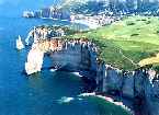
Much of this province is reminiscent of a great landscape painting, with cattle grazing sleepily in verdant fields. But the rustic wood-framed houses are contrasted alongside the nearby modern buildings. Not far from the Seine, a mere hour drive from Paris, is Giverny where Monet painted his water lilies. Here and there you can still find stained-glass windows and Gothic architecture miraculously spared the bombardments; however, many great buildings were leveled to the ground. And Normandy’s wide beaches may attract families, but in August the Deauville sands draw the choicest of the chic from Europe and North America.
Normandy is the land of Calvados brandy and apple cider [bon bere]. It is well known for its rich butter, cream and other dairy products. The region is world renowned for its culinary tour de force: sauce Normande, tripe a la mode de Caen, sole Dieppe, canard a la Rouen, and soufflé like omelets from Mont-St-Michel. Poule d’Auge, poule de Bresse, andouillet (tripe sausage) de Vire, moules d’ Isigny, hueters de Courseulles, fuite de mer d’Honfleur, and the highly prized lamb (pré salé) that is raised on the salt meadows of Normandy.
Supple Camembert, which is made from cow’s milk, has been sold in a wooden box since 1880, is well known. Lesser known cheeses of the area, are equally tasty. These include Pont-L’Evêque and Brillat-Savarin. The latter with a high fat content of 75%, was invented in the 1930s by the cheese merchant Henri Androuët. His family established the once famous restaurant Androuët, on rue d’Amsterdam, in Paris, which specialized in sauces made from cheese.
Normans consume cider at nearly every meal. Bon bère is the term for true cider, and sometimes it’s so strong that it must be diluted with water. It takes 12 to 15 years to bring Calvados to taste perfection (in America Calvados may be called apple jack).
Many a Norman finishes a
meal with black coffee and a glass of this strong drink, which is
also used to flavor main courses.
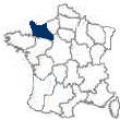
The region of Lower-Normandy
is composed of the northwestern French départements of Orne [61], Calvados [14], and Manche [50]. It was formerly western Normandy . The capital is
Caen. The region is bounded by the Départements of Ille-et-Vilaine, Mayenne, and Sarthe to the south and Eure-et-Loir and Eure to the east. Manche and Calvados border the English Channel.
The
History of Lower Normandy
Normandy takes it's name from the
Normans during the early middle ages. The Normans were a
mixture of Gauls and Vikings who laid siege to Paris under the
leadership of Rollo, thus he was given the area of Normandy in
return for his defense of the area against pirates.
William, the Duke of Normandy was Rollo's descendent, and in 1066 he
invaded England [the last to successfully invade England] and became
King William I of England. The area remained under English
rule until 1087. Several battles from 1106 through 1214 took place,
and during the
Hundred Years War Normandy was occupied by the English.
Normandy prospered
after the Hundred Years War and the Wars of Religion, due to the
fact that several major towns joined the Reformation, and more
battles ensued throughout Normandy. Normandy during the
French Revolution tended to support the Federal Republic rather than
that of the Jacobins in Paris.
Normandy was the turning point during World War II, with the
successful [but very costly in soldiers lives] D-Day invasion
of German occupation of France, by allied troops. To visit the
Normandy D-Day memorials and battlefield areas,
click here.
The
Geography of Lower Normandy
The uplands of the Massif Armoricain extend into Manche and western Calvados and Orne; eastern Calvados and Orne are a part of the Paris Basin. A humid climate prevails, with annual precipitation in the Cotentin peninsula of Manche approaching 35 inches (900 mm).
The Culture of Lower Normandy
Basse-Normandie is sparsely populated. The process of rural depopulation, which characterized much of France in the 19th and early 20th centuries, was especially pronounced in Basse-Normandie, whose population declined by more than 38 percent between 1851 and 1946. It has subsequently grown, and most of the recovery has occurred in Calvados, which has benefited from the growth of
Caen.
The Gastronomy of Lower Normandy
The gastronomy of Normandy in general tends to run to the
fish and seafood dishes, since it is fresh and abundant. However,
they have some wonderful lamb, chicken and duck dishes that are
quite wonderful.
Normandy is famous for it's butter, there is no match in American
butters. Then the following four cheeses are well noted
worldwide. Each is quite distinctive, and should be sampled -
you're sure to find one or more become a favorite of yours.
The great Normandy cheeses are Camembert [it's been around for
hundreds of years], and between that and Brie are the two most
consumed French cheeses worldwide. Then there is
Brillat Savarin, a wonderful
triple cream fhat Andouet created, Neufchâtel
[similar but creamier and lighter, with a more distinguishing taste,
than regular cream cheese], and the two 'stinky' cheeses of Livarot
and Pont L'Evêque. These French cheeses are unsurpassed as far
as quality and taste compared to similar cheeses made in the U.S. or
elsewhere.
The
Economic Activity of Lower Normandy
Animal husbandry dominates agriculture. The regions of Auge in Calvados and Perche in Orne are major producers of beef. Camembert cheese is produced in Orne; Pont-l’Évêque and Livarot in Calvados also produce fine cheeses. Large numbers of horses are raised in Manche. Port-en-Bassin in Calvados and Cherbourg are major fishing ports. Industries are concentrated around Caen, whose manufactures include electronic goods and
Citroën automobiles. The production of iron, which is concentrated around Caen in May-sur-Orne, Soumont, and Potigny, is in decline. Orne has benefited from the decentralization of Parisian industries since 1950. Tourism is being developed along the coast of Calvados between
Honfleur and Cabourg.
The Region of Lower Normandy
Town Information & the
Towns of Lower Normandy
|
Alençon
Bayeux
Bayeux is a town on the Aure River, in the Departement of
Calvados, not far from the English Channel. It is located 16 miles west-northwest of
Caen on Route National 13, at its juncture with D572 and D6. It is 166 miles northwest of
Paris.
The site was first known as Baiocasses to the Gauls. To the Romans, it was first known as Augustodurum. Subsequently, as an important Roman city, it was called Civitas Baiocassium.
In the 4th century Bayeux became a bishopric. Rollo, the Viking, captured the town in 880. Subsequently, it became a Norman stronghold. In 1106, Henry I of England pillaged the town. During
the Hundred Years’ War, from 1337 to 1453, and during the Wars of Religion, from 1562 to 1598, the town was besieged and taken various times.
The Germans occupied Bayeux in 1940. The Allies took the town on the day after D-Day, June 7, 1944. It was the first town liberated, and it was the first to greet General de Gaulle on his return to France, June 14, 1944. On June 16, de Gaulle set out, in a broadcast speech to the French people, his principles for a new constitution.
Although Bayeux is only a short distance behind the D-Day invasion beaches of Omaha and Gold, it was spared a bombardment. Today, it is a sleepy, small town with cobblestone streets lined with small shops and Norman style timbered houses dating from the 17th century.
Bayeux’s 13th through 19th century Gothic Cathedral of Notre-Dame de Bayeux is in the town’s center. It has 11th century Romanesque towers, a groin-vaulted crypt, which is decorated with 15th century frescos of angles, and lower nave.
The City Hall [Hotel-de-Ville] was once the 11th through 14th century Bishop’s Palace. A museum and the law courts are housed in the Hotel-de-Ville. The Musée de la Reine Mathilde displays the Bayeux Tapestry. This large embroidery tells the story of the Norman Conquest of England in 1066.
The medieval Tapestry [Tapisserie de la Reine Mathilde] is probably the world’s most famous embroidery. It is remarkable both as a source of 11th century history and as a work of art. It is an invaluable historical representation of the arms, costumes, manners and ships used by the Normans prior to the invasion.
The Tapestry is 231 feet long and 19.5 inches wide. It was made of a seamless strip of linen, embroidered with 8 colors of woolen thread. It is a needlework panorama of 72 scenes, and 1512 figures [with identifying Latin inscriptions], of the Norman Conquest. It tells of Harold’s failure to honor the oath, he gave at Bayeux recognizing his cousin William’s right to succeed Edward the Confessor, and its consequences. The borders are decorated with animals and scenes taken from fables. It was probably made in England soon after the conquest. But, it wasn’t used until about 1476, when it decorated the nave of the Bayeux Cathedral.
Some believe that the tapestry was the work of
William the Conqueror’s wife Matilda of Flanders. However, her involvement with the Tapestry is in doubt. Others believe that it was commissioned by Odo, the bishop of Bayeux and half brother of William. Odo is depicted in some of the latter scenes. The work is dated no latter than 1092.
Across from the cemetery is the Musée Memorial de la Bataille de Normandie. The museum houses the story of the Battle of Normandy that took place between June 6 and August 22, 1944.
Bayeux products include dairy foods, lace, plastics and pottery.
Return to top
Caen
The capital of the
Calvados Departement and of the region of
Basse-Normandie is Caen. It is located on the Orne River, 9 miles from the Channel, within an agricultural region. The city is 51 miles southwest of
Le Havre, 63 miles east-southeast of Cherbourg, 60 miles west-southwest of
Rouen and 147 miles west-northwest of
Paris. It is at the juncture of the Autoroute A13 and Routes National 13, 175 and 158 and D562.
The area, of which Caen is a part, was invaded by the Norsemen during the 9th and 10th centuries. In the 10th century, Caen first became important under the dukes of Normandy. It was
William the Conqueror’s favorite city in the 11th century. During
the Hundred Years’ War, 1337 through 1453, the English, under Edward III, captured the city in 1346. The English again occupied the city, led by Henry VI, from 1417 to 1450. During the occupation, in 1432, Henry VI of England established a
university in the city.
Following the revocation of the
Edict of Nantes, in 1685, the Protestant city’s prosperity plummeted with the emigration of its populace. During the French Revolution [1789 to 1799], Caen was the focal point for the anti-Revolutionary Girondist movement.
In about 1050, William the Conqueror and Matilda of
Flanders were married. Because they were distant cousins, the pope excommunicated them. In 1059 they managed to ‘atone’ for their sin by each founding an abbey. The late 11th century austere Norman Romanesque Church of Saint-Étienne, at the Abbaye-aux-Hommes [on the east side of Caen], was founded by William. His tomb is located there. The Norman Romanesque Church of La Trinité, at the Abbaye-aux-Dames on the west side of the city], was founded by Matilda. Her tomb is located there. Both structures were unscathed by the war.
Both abbeys are beautiful structures done in the Norman Romanesque style, and both were constructed of ‘Caen stone’, a light creamy-yellow Jurassic limestone. This stone was also a popular building material with the Normans in England.
The château-fort that overlooks the city was built by William in 1060. The Romanesque Church of Saint-Étienne, which was started in 1066, was also constructed using ‘Caen stone’. It has two, 295 foot towers. The towers are topped by 13th century octagonal spires. The church’s lantern-tower is considered a masterpiece.
The Church of Saint-Pierre is principally of Gothic design with French Renaissance embellishments. It is located at the southern base of the château, between the churches of Saint-Étienne and La Trinité.
In the 19th century, a 9 mile long ship canal was constructed between the city and the English Channel at Ouistreham.
During the Battle of Normandy, June 6 to August 22, 1944, Caen became the center of German resistance to the Allies. During the British-Canadian advance, over two-thirds of the city was destroyed.
In 1957, the
University of Caen was reopened at a new site. The city also has several noteworthy trade schools.
The city’s products include automobiles, electrical appliances, electronics, gloves, lace, steel [that is exported via the canal] made of iron-ore from the nearby Orne Valley, and textiles.
Return to top
Cherbourg
|
Coutances
The hilltop town of
Coutances overlooks the Cotentin peninsula in the Manche Departement of the region of
Basse-Normandie. It lies near the English Channel, on the Soulle River, about 170 miles west of
Paris and 16 miles west-southwest of Saint-Lô. It is at the intersection of D2, from Cherbourg, D971 from Carentan and Granville and D972 from Saint-Lô.
The area was originally inhabited by an
ancient Celtic tribe called the Unelli. When the Romans came they called the town Cosedia. They latter changed the name to Constantia, in the 3rd century, to honor the emperor Constantius I.
Coutances became an Episcopal see during the 5th century. During the Middle Ages it became the seat of a viscount. Over the course of the centuries, the town was subjected to a long history of sieges.
In 1940, it was occupied by the Germans. Coutances was one of the first towns to be taken by the Allies after the July 44 breakthrough at Saint-Lô.
The small town was badly damaged during World War II battles between the liberating Americans and the retreating Germans, but the cathedral escaped serious damage. Work started on rebuilding the town, according to a master plan, in 1950. The master plan was oriented towards accentuating the town’s old churches and other monuments.
The mainly 13th century Gothic Cathedral of Notre-Dame dominates the town. It was originally built upon the site of an older church that was begun by a prominent local family around 1040. The present building, which was constructed between 1220 and 1275, used the remains of the old church. It is a slender example of local Norman architecture and the Gothic style with Gothic stained windows. Its octagonal lantern tower raises to 135 feet and is flanked by turrets. It wasn’t until the 13th century that its double flying buttresses were added.
Several blocks directly west is a Botanical Gardens [Jardin des plantes]. A court of assizes, and tribunals of the first instance and of commerce, are located several blocks to the north of the cathedral.
Coutances’ is a market town for the Manche Departement. Its products are mainly from the tanning and manufacturing industries. The breeding of Normandy dairy cows is centered here.
Return to top
Honfleur
Honfleur is a charming small fishing town, yacht harbor and tourist center situated on the southern bank of the Seine River Estuary in the Departement of
Calvados. It is directly south of, and across the Bassin de Retenue from, Le Havre and is directly linked to that city by the Normandie suspension bridge. It is about 45 miles west of
Rouen, 39 miles northeast of
Caen and 125 miles west-northwest of
Paris. It is at the crossroads of D513, from Trouville and Deauville and D579 from Pont-l’Évéque.
Honfleur was founded in the 11th century. During
the Hundred Years’ War, which lasted from 1337 to 1453, Honfleur changed hands many times. The English last occupied this major defensive port from 1418 to 1450. Over the course of the 16th through 19th centuries, the port’s importance increased as a result of its substantial trade with Asia and North America.
In 1608, Samuel de Champlain sailed from the port to found Québec. During the 19th century,
Le Havre became much more important than Honfleur as a seaport. Instead, Honfleur, because of its colorful charm, became a Mecca for artists and writers. Boudin, Cézanne, Courbet, Pissarro, Renoir and Sisley all painted there.
The picturesque 17th century Vieux-Bassin is encircled by 15th and 16th century buildings, with six and seven story houses on the western side. On the east side is the town’s old fortified area, l’Enclos. Surrounding the Vieux-Bassin are many varieties of colorful flowers.
The 14th through 15th century Church of Sainte-Étienne houses the Musée de le Vieux-Honfleur. The museum holds folkloric and maritime displays.
The 15th century Church of Sainte-Catherine, located on the northwest side of the Vieux-Bassin, was constructed of timber, by ship carpenters, and appears as an upside down ship. Nearby, is the Musée Eugène Boudin housing many Boudin works and paintings by the likes of Raoul Dufy.
Honfleur is known as a tourist center and as one of Normandy’s most appealing harbors. Its main manufacture is furniture.
Return to top
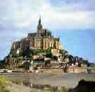
Mont-Saint-Michel
Mont-Saint-Michel is a small, rocky, cone-shaped island in the Gulf of Saint-Malo, located just off the cost of the Departement of
Manche. It is situated at the far northwestern edge of
Basse-Normandie where it borders
Brittany. It is about 11 miles west-southwest of Avranches, 32 miles east of
Saint-Malo, 63 miles southwest of
Caen, 41 miles north of
Rennes and 201 miles west of
Paris. The island is the northern terminus of Departemental route 976 from Rennes, just 5 miles north of its intersection with Route National 175.
Originally, the islet was known as Mont-Tombe. In the 8th century, the bishop of nearby Avranches, Saint-Aubert, had a vision of the archangel Saint-Michel. In commemoration, he built an oratory on the 256 foot high granite outcropping and named it Mont-Saint-Michel.
The Benedictines built an abbey, on this spot, in 966.
King Philip II of France tried to capture the Mont in 1203, but merely succeeded in partially burning down the abbey. Philip paid for his folly by underwriting the construction of the three-tiered La Merveille buildings, on the north side of the Mont. These buildings rise majestically to the pointed spire of the abbey church.
In 1256, the island was fortified. From 1337 to 1453, during
the Hundred Years War, and from 1562 to 1598, over the course of the Wars of Religion, the fortified island resisted many sieges. During the Hundred Years’ War it was the only part of northwestern France to remain constantly in French hands.
During the 18th century, the monastery substantially declined. By the beginning of the French Revolution, in 1787, the French government had dissolved the monastery. At that time there were but seven monks in residence. Under
Napoléon I, who reigned from 1804 to 1815, Mont-Saint-Michel became a state political prison until 1863. In 1874, the
French government designated it as an historic monument and restored it. It was connected to land by a 3000 foot long causeway built in 1875.
During the Middle Ages, the island was completely surrounded by water. Prior to the causeway’s construction, it was only surrounded by water at two high-tides per month. Today, its tides are the highest on the continent, with a low-tide/high-tide differential of 50 feet at certain times of the year.
A massive wall, more than ½ mile in circumference, encircles Mont-Saint-Michel. The narrow Grande-Rue cobblestone street circles up to the monastery in three steep spirals. It is bordered, at its lowest level, by old houses, some of which are from the 15th century. Today, they are mostly hotels, restaurants and tourist shops.
La Merveille was built in 1228. Its powerful walls combine the robustness of a fortress with a religious simplicity. On the southern and eastern sides of the medieval walls is a panoramic view of the bay. On La Merveille’s second terrace is the Salle des Chevaliers. It is a 13th century banquet hall and one of the largest and most beautiful rooms at Mont-Saint-Michel.
The 11th through 16th century Romanesque and Gothic style Église Abbatiale is perched upon the top of the granite outcropping, overlooking the bay. In the 19th century the tower, spire and the statue of Saint-Michel were added.
In 1979, UNESCO designated Mont-Saint-Michel as a World Heritage site. It is France’s most splendid abbey and one of France’s greatest tourist sites. Because of its combination of history and architecture, it has been called ‘the Wonder of the Western World’.
Return to top
Saint-Lô
|
|
|
The Region of Lower Normandy
is composed of three
Départements: Orne [61], Calvados [14] and Manche
[50]. |
The following links to lists of the towns and villages, by Départements [with population], with a link to each location's tourist office for phone, fax and address: The Département of
Calvados [14]; | The Département of
Manche [50]; | The Département of
Orne [61];
|
|
|
|
|
|
|
|
|
|
|
| |
|
|
|
|