| |
The Region of Centre
~ France Region 6
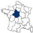
Has six Départements: Cher [18], Eure-et-Loir [28], Indre [36],
Indre-et-Loire [37], Loir-et-Cher [41] & Loiret [45] |
 |
|
Introduction to the Region of
Centre - the Loire Valley -
France Region 6 of 22
|
The Location of Centre [6]
The administrative Region of Centre lies in the
Paris Basin and covers much of north central and central France, including the central part of the
Loire Valley.
It is boardered by the regions of
Haute-Normandie and
Ile-de-France to the north,
Bourgogne to the east,
Auvergne to the southeast,
Limousin to the south,
Poitou-Charentes to the southwest,
Pays de la Loire [Western Loire] to the west and
Basse-Normandie [Lower Normandy] to the northwest.
The Centre Region is composed of six départements:
Eure-et-Loire is its most northern département;
Loiret is in the northeast corner of the region;
Cher is positioned in the region’s southeast corner;
Indre is in the south;
Indre-et-Loire is in the southwest and
Loir-et-Cher is in the northwest, between Loiret and Indre-et-Loire.
The region’s capital is
Orléans, which is about 75 miles south of
Paris.
The History of Centre
A powerful people, known as the
Cenomanni, inhabited the Loire Valley during the Iron Age.
Their decendents, the Carnutes, vigorously opposed the Roman Conquest in 52 BC.
Subsequently, they and the Druids unsuccessfully revolted against
Caesar.
Emperor Augustus finally brought about peace and stability that encouraged such towns as Angers, Le Mans,
Orléans and
Tours to organize along the Roman model with baths, forums, theaters and other public buildings.
During the early part of the Christian era, the first Bishop of
Tours, Saint-Gatien, was introducing Christianity to the area.
By the 4th century, Saint-Martin, the greatest of all Gallic bishops, had assured complete acceptance of Christianity in the region.
In the middle of the 5th century the Huns had invaded as far west as
Orléans on the Loire.
In 451, the invaders were stalemated by Bishop Aignan who held them, at Orléans, until help arrived.
In 507, the Frankish king
Clovis conquered the area.
The Saracens pushed north from Spain into the Loire in 732.
They were defeated by the Caroligian king, Charles Martel.
In the middle of the 9th century, the Vikings raided the area bordering the Loire River.
They were repulsed by Robert, the Count of
Blois and
Tours.
However, their raids continued as late as 911, when the Duchy of Normandy was created by the Treaty of Saint-Clair-sur-Epte.
By the time of the 11th and 12th centuries, the age of the powerful Loire barons, the Loire Valley was doted by imposing chateaux.
Only Orléans was firmly in the hands of the French crown.
However, in 1202, John of England’s French lands were seized by
Philippe-Auguste and the entire Loire became French again.
Under the
Capet kings, the 11th and 12th centuries were also the period when feudalism flourished in the Loire Valley.
A hierarchical pyramid descended from the king to the nobility, and from them to the knights.
The fief was a grant of land to the nobles that was then subdivided by a lord and, in turn, granted to a knight, or to another.
The grant’s recipient then became the grantor’s vassal who owed his grantor certain economic and military obligations.
From 1337 to 1459, during the
Hundred Years' War, the English reconquered most of the Loire and besieged Orléans.
In 1429, Joan of Arc rallied the people of the Loire to drive the English out of France.
She, and her army, attacked the English at Orléans and freed the city.
The Renaissance, which shed its light over the
Loire Valley during the 16th century, was highly dependant upon the availability of printing presses.
The first Loire press was set up in 1477 at Angers.
Charles VII,
Louis XII and
François I became driving forces of the Loire Renaissance.
This Renaissance expressed a new way of thinking about beauty in poetry, music, religion and architecture; the latter being manifest in the chateaux at
Amboise,
Azay-le-Rideau,
Blois,
Chambord and
Chenonceau and the graceful mansions that were erected in the towns.
During the Renaissance, the power of the Catholic Church diminished along the Loire Valley.
But, by 1540, the Roman Catholic Church lashed out at the Renaissance inspired Reformation with uncompromising repression.
In turn, Protestant Huguenots rose up against the Catholics in 1560.
Thus, the brilliant period of the Loire finished in tragedy.
The 17th and 18th centuries saw the Catholic Church re-established.
There was an increase in the number of convents and seminaries and a decline in the Protestant movement in the Loire.
The Edict of Nantes’ revocation, in 1685, became the death- blow to Protestantism in the Loire.
The economy of the Loire accelerated dramatically during the 17th century, with a growth in agriculture and textile production. But, the textile industry, together with other sectors of the economy, fell into decline during the 18th century. The French Revolution contributed to this decline by pitting one part of the Loire against the other.
On the one hand, the inhabitants of the towns quickly saw the benefits of the Revolution whereas the rural peasants were opposed to it.
Furthermore, the areas of Maine and Anjou rose up against the Revolution, while the people of Orléanais and Touraine supported it.
In the end, the Revolution left entrenched bitterness and widespread ruin in its wake.
1870 was a bad year for France.
The Empire had already fallen when the
Franco-Prussian War exploded upon France.
Within a short period, of the beginning of hostilities, the Bavarians had quickly captured
Orléans.
The army of the Loire was then formed under General d’Aurelle de Paladines.
Part of this army routed the Bavarians at Orléans while the other part tried, unsuccessfully, to check the advance of the Prussians at Le Mans. The government was consequently evacuated to
Bordeaux.
A second Army of the Loire was formed, under General Chanzy, and engaged the Prussians east of Le Mans.
It was forced to retreat.
On January 28, 1871, the armistice was signed.
During the first World War,
Tours served as the headquarters for the American Expeditionary Force.
Shortly after the commencement of the Second World War, the French Government moved to Tours and then subsequently to
Bordeaux.
On October 24, 1940,
Marshal Pétan went to Montoire, in the Loire, where he met Hitler and agreed to his terms for an Armistice. Control of the Loire was retaken by the Resistance and Allied forces in September, 1944.
The Region of Centre was created in the 1970’s to be coextensive with the former historic provinces of Berry, Orléanais and Touraine.
The Geography of Centre
The center part of the Loire forms a part of the
Paris Basin. During the earliest geologic periods, this area was partly enclosed by the ancient crystalline masses known as the Armorican and Morvan Massifs.
During a secondary era, the area was covered by the sea and limestone formed.
In a latter era, the folding of the Alpine mountain zone formed the Massif Central, that completed the encirclement, and the sea retreated for good.
Centre is bisected by the east-west flowing Loire River.
The region’s highest point is the 1653 foot Mount Saint-Marien which is located in the Département of
Cher.
The Culture of Centre
The cultural heart of the Centre Region is the
Châteaux de la Loire, which it shares with the adjacent region, to the west, the
Pays de la Loire [Western Loire].
This vast and rich cultural area is known for its imposing cathedrals, such as at
Chatres, and its many Renaissance châteaux that were built by ambitious kings [and queens] in remarkable locations along the Erdre, Eure, Layon, Loire, Saribe, Sèvre and Sologne river valleys.
Some of the more impressive castles, that they built, are
Amboise,
Azay-le-Rideau, Blois,
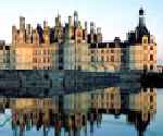
Chambord,
Chenonceaux,
Cheverny and
Villandry.
The Introduction to the Loire Valley
The Gastronomy of Centre
-
The Wine
-
The Cheese
-
The Cuisine
The Economic Activity of Centre
-
The Agriculture
Centre is known for its Cabernet, Pinot and Sauvignon grapes, and is a leading producer of barley, corn and wheat.
It also produces rapeseed, sugar beets and sunflowers.
-
The Tourism
The tourism industry, in centre, is centered about the region’s
Loire Valley châteaux and the area’s impressive cathedrals at
Chartres,
Orléans and
Tours.
-
The Industry
The region’s manufacturing has grown since 1945, in part because of the region’s three nuclear powerplants, located at Avoine-Chinon, Dampierre-en-Burly and Saint-Laurent-des Eaux.
Automotive parts, ball bearings, tires and plastics are among its production.
|
|
Region of
Centre Loire Valley Département Information
|
Cher [18]
The Département of Cher is situated in the southeast corner of the region.
It was created from small parts of the old provinces of Bourbonnais and Nivernais and from the eastern part of the historic province of Berry. It is bordered by the Département of
Loiret to the north, Nièvre to the east,
Allier to the southeast,
Creuse to the south,
Indre to the southwest and
Loire-et-Cher to the northwest.
The Allier and Loire rivers flow to the département’s east and the département’s surface consists primarily of agricultural and wooded land.
Just to the west of
Bourges, which is located just south of the middle of the département, the Cher River flows in a northwesterly direction.
Logging takes place in the département’s north and west and there is beekeeping, cattle raising, viticulture and wheat farming elsewhere.
The vineyards, overlooking the Loire River, near the ancient village of Sancerre, are world renown.
The département’s industry includes armaments, aircraft, agriculture machinery, chemicals, clothing, porcelain and metalwork.
Cher’s industrial activities are centered primarily around Bourges and Vierzon.
There are three arrondissements for the Département of Cher:
Bourges, Saint-Amand-Montrond and Vierzon.
The départemental capital is the cathedral city of
Bourges.
Eure-et-Loir [28]
The Département of Eure-et-Loir is mostly situated on the
Paris Basin.
It was configured, in 1790, from parts of the old provinces of
Normandy and Orléanais.
It is bordered by the Départements of Eure and Yvelines to the north, Essone and
Loiret to the east,
Loir-et-Cher to the south, Sarthe to the southwest and Orne to the west.
Most of the département’s population is rural.
More than half of the département’s area is composed of the Beauce plain, one of the most productive plateaus in France. It is a treeless area of isolated grain farms and large villages.
The Thimerais region, to the northwest, encompasses wooded areas and grasslands. To the southwest is the hilly Perche; the rolling hills of the Hurepoix are to the northeast.
The Eure and Loir rivers give their names to the département.
The Eure flows northward through the capital,
Chartres.
The Loir flows southward through Châteaudun.
The département is divided into the four arrondissements of Chartres, Châteaudun, Dreux and Nogent-le-Rotrou.
Chartres, famous for its world famous High Gothic cathedral, which was consecrated in 1260, is the capital of the département.
Eure-et-Loir’s products include flour, leather and agricultural machinery.
Indre [36]
Parts of the historic provinces of Berry, Marche, Orléanais and Touraine were used to create the relatively flat Département of
Indre.
Indre is the southern most département in the Region of
Centre.
It is bounded by the Département of
Loir-et-Cher to the north,
Cher to the east,
Haute-Vienne and
Creuse to the south, Vienne to the southwest and
Indre-et-Loire to the west.
Indre’s topography slopes from the Massif Central, in the south, to the north.
It is mainly drained by two rivers, the Indre in the north and the Creuse in the south.
The Indre River, a tributary of the Loire, flows from the southeast through
Châteauroux to Châtillon in the northwest.
The Creuse River roughly parallels the Indre’s flow.
The Brenne, in the west, is an area covered with marshlands and small lakes.
The département’s north and center are wooded.
To the northeast, the land becomes agricultural.
The Boischaut, a wooded, hilly area in the south, follows the course of the Creuse River Valley.
The river has been dammed for the hydroelectric power plant near Éguzon.
The département is divided into the four arrondissements of Châteauroux, La Châtre, Issoudun and Le Blanc.
Châteauroux, the département’s capital, was originally just the 10th century castle built by Raoul le Large, lord of Déols, called Château-Raoul.
Indre is primarily an agricultural economy, but there is industrial activity, in the area of Châteauroux , consisting of aircraft, metalwork, plastics, textiles and tobacco.
Tourism is also important.
The
Châteaux of the Loire attract many tourist in the north and the Creuse River is frequented by tourist in the south.
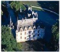
The magnificent Renaissance Château of Valencay, that once belonged to
Talleyrand, is in
Indre.
There is also an 11th century circular church at Neuvy-Saint-Sépulchre.
To the département’s center, and to its west, other medieval churches abound.
The village of Nohant
is the location of George Sand’s much frequented
Château, which is now a museum.
|
Indre-et-Loire [37]
The Département of Indre-et-Loire, which is known as the ‘Garden of France’, was created from the better part of the historic province of Touraine together with pieces taken from the old provinces of Anjou and Orléanais.
Indre-et-Loire is in the western part of the
Centre Region.
The département is bounded by the Département of
Loir-et-Cher to the northeast,
Indre to the east, Vienne to the southwest, Maine-et-Loire to the west and Sarthe to the northwest.
Indre-et-Loire is known for the contrast between its somewhat wooded, but mostly barren uplands and its fertile valleys.
There are four navigable rivers:
The Cher, the Creuse, the Loire and the Vienne.
The Loire, which flows through
Tours, traverses the département and joins with the Cher, Indre and Vienne in the southeast.
The Gâtine de Touraine, between the Loir and Loire rivers is one of the département’s sparsely wooded plateaus.
There are three arrondissements in the département: Chinon, Loches and Tours.
The ancient capital of the historic province of Touraine,
Tours, is the département’s capital.
Tours was also a center of learning in the early Middle Ages.
The economic activity of the département consists of agriculture, tourism and some industry.
The département’s agricultural activities include lush pastures for grazing, varied orchards and vineyards that produce such well known wines as Bourgueil, Montlouis and Vouvray.
Its tourism is centered about the chateaux such as
Amboise,
Azay-le-Rideau,
Chenonceaux, Chinon, Langeais and Loches.
The chemical, electrical [there is a nuclear power station at Avoine] and the pharmaceutical industries have been especially active in the
Tours area.
Loir-et-Cher [41]
Loire-et-Cher, which is known for its 15th and 16th century châteaux, was created from the southwestern part of the historic province of Orléanais and from parts of the old provinces of Maine and Touraine.
The département is located in the west-center part of the region, and is bounded by the département of
Eure-et-Loir to the north,
Loiret to the northeast, Cher to the east, Indre to the south,
Indre-et-Loire to the southwest and Sarthe to the west.
The département’s north is a large, wheat growing plain.
To the south, cattle are bred in a marshy and forested area.
The Loir River flows through the towns of Vendôme and Montoire-sur-le-Loir in the département’s northwest.
The Loire, which flows northeast to southwest, bisects the département. The Cher River flows through Mennetou-sur-Cher and Montrichard in the south.
Both the Loire and Cher are navigable.
The Département of Loir-et-Cher is administratively divided into the three arrondissements of
Blois, Romorantin-Lanthenay and Vendôme.
The département’s capital is at
Blois.
The département’s economic activity has been dynamic, but is mostly agricultural. Mixed farming predominates in the wooded hill country, northwest of the Loir, known as Perche.
Between the Loir and Loire Rivers, the prolongation of the Beauce plateau is a grain raising area.
The
Loire Valley itself is known for its viniculture, fruit and vegetables. In the Sologne, asparagus is the important crop.
The nuclear power generating plant, that was built on an artificial island [Saint-Laurent-des-Eaux] in the Loire just to the northeast of Blois, has been responsible for an industrial Renaissance in the area.
There is a strong wool industry concentrated near Romorantin-Lanthenay.
Thousands of tourists are attracted annually by the charming châteaux at Beaugency,
Blois,
Chambord and Chaumont.
Loiret [45]
The Département of Loiret was formed mainly from the eastern part of the old
province of Orléanais.
It is located in the region’s northeastern corner.
The département is named for the eight mile long Loiret River, that originates from springs fed by the Loire River, south of
Orléans. Loiret is bordered by the Département of Essonne to the northwest, Seine-et-Marne to the northeast, Yonne to the east, Nièvre to the southeast,
Cher to the south,
Loire-et-Cher to the southwest and
Eure-et-Loire to the west.
The département’s topography is basically flat. Its lowest point of 174 feet is in the low rolling hills of the Gâtinais, in the département’s northeast; its highest point is a
hill, on the wooded Sologne plain, that is 825 feet above sea level.
To the north of the Loire River, the soil is extremely fertile whereas the soil to the south is poor and is covered with forests.
The Loire River, as it flows through Loiret, forms an arch.
It enters from the southeast, flows northwest from Gien to Chateauneuf-sur-Loire, west-northwest to Orléans and then southwest through Meung-sur-Loire, Beaugency and Avaray.
The Essonne and Loing rivers flow through the
département’s northeast.
Both are tributaries of the Seine.
The Seine, in turn, is linked to the Loire, and its canal, by the 17th century Briare and Loing canals.
Loiret is divided administratively into the three arrondissements of Orléans, Montargis and Pithiviers.
The département’s capital is at
Orléans.
Loiret’s agriculture consists of barley, corn and wheat cultivation on the Beauce Plateau and beekeeping and mixed farming in the Gâtinais.
Loiret’s Loire Valley cultivation of vineyards for vinegar nearly equals that of all the other areas of France.
Loiret’s industry is centralized around Orléans, with pottery at Gien and tire manufacturing at Montargis.
The département’s tourism is centered about Orléans and the ancient châteaux of Beaugency and Sully.
Another popular tourist attraction is the unique 9th century Byzantine mosaic at the abbey church of Saint-Benoît-sur-Loire.
For information on the Chateaux of the Loire Valley, hours and information on site seeing and other great chateau monuments around France
click here.
|
The Region
of Centre - the Loire Valley
Town Information
The Information on the Towns of Centre
| |
Blois
Blois is located midway between
Tours and
Orléans on a hill, overlooking the north bank of the Loire River.
The Beauce is to the north and the Sologne is to its south.
The town is located on Route National 152, which runs along the Loire River, at the intersection of D 957.
It is just south of the Auto Route A 10.
Blois is about 100 miles south of
Paris, 33 miles east-northeast of
Tours and 33 miles southwest of
Orléans.
Blois is the capital of the Département of
Loir-et-Cher.
The first mention of Blois was in the 6th century by Gregory of Tours.
During the early Middle Ages it became the capital of the counts of Blois, the antecedents of the
Capetian French kings.
The counts of Blois were among France’s most powerful feudal lords, from the late 10th through the late 12th century, controlling two estates –
Champagne and the area of Blois and
Chartres.
In 1135, the son of the Count of Blois, and the daughter of
William the Conqueror, became the king of England.
In 1234, the Count of Champagne
sold the County of Blois to
Louis IX.
Blois was subsequently acquired, towards the end of the 14th century, by the duc d’Orléans, Louis de France [the brother of
Charles VI].
Blois then became the site of the court of Orléans.
In 1429,
Joan d’Arc left Blois to commence the siege of
Orléans.
In 1462,
Louis XII was born at the château.
In 1498, Louis XII, succeeded
Charles VIII to the French throne and the Blois château became the royal residence.
He was the son of Duke Charles and the grandson of Duke Louis, and had been born in the
Château at Blois.
Consequently, Blois became the quasi capital of France until the end of the 16th century.
Upon assuming the throne in 1515,
François I, who divided his time between
Amboise and Blois, began the rebuilding of the Château using Italian architectural elements.
On December 23, 1588,
Henry III had Henri de Guise, who was plotting Henry’s downfall, murdered on the château’s second floor.
Eight months latter, Henry III was murdered by an assassin’s knife.
Subsequently,
Louis XIII imprisoned his mother, Marie de Médicis, in the château; she escaped two years later.
In 1626, Louis XIII gave his brother, Gaston de France, duc d’Orléans, the country of Blois and the duchies of Orléans and
Chartres.
Gaston hired François Mansart to design the castle’s classical wing.
The Château de Blois was begun, in the 13th century, as a feudal castle.
It was worked on until the 17th century.
The States-General’s hall, the castle’s main hall, was completed in the 13th century.
In the mid 15th century, the Charles d’Orléans’ Gallery was built.
The
Louis XII Wing and the Chapelle Saint-Calais, which made the transition between the Flamboyant Gothic and the French Renaissance, were constructed between 1498 and 1503.
Between 1515 and 1524, the strictly Renaissance François I façade was completed.
Its spiraling staircase, in an octagonal well, reaches the height of 5 stories.
Its elaborately ornamented balustrades prominently display the kings symbol, the salamander.
Blois is the center of an area that produces mainly wheat.
It has long been an important market for asparagus, corn, wine and brandy.
Shoes, and other footware, are made in the town as is a fine chocolate.
The town boasts of a number of Gothic and Renaissance buildings and picturesque ancient streets.
It is one of the major tourist centers of the
Loire Valley.
Bourges
Bourges is located on the northern edge of the Massif Central, at almost the exact center of France.
It is at the confluence of the Canal du Berry and the Auron and Yèvre rivers.
The town is 34 miles northeast of
Châteauroux, 148 miles south of
Paris, 70 miles south-southeast of
Orléans, 60 miles southeast of
Blois and 72 miles east-southeast of
Tours.
Once the capital of Berry, then
Aquitaine, Bourges is now the capital of the
Cher Département.
Bourges is located on the site of an ancient
Celtic capital whose chieftain,
Vercingetorix, was defeated by
Julius Caesar in 52 BC.
The Romans massacred its 40,000 inhabitants during the conquest.
The town then became the important Roman settlement of Avaricum [town of abundant water], with a river port, consisting of a harbor and wharves.
Avaricum also had a vast Roman amphitheater.
The town flourished until the coming of Saint-Ursin who brought Christianity with him in the 3rd century.
It became an archiepiscopal see.
In 1101 the town became French.
Charlemagne unified Berry [named for the
Bituriges Celts of the region] and Bourges became the capital of the duchy of Berry by the 14th century.
From 1360 to 1416, Duke Jean de Berry spent a fortune on commissioning works of art for the town.
During
the Hundred Years’ War [1337 and 1453], when other parts of France were in English hands, Bourges was the capital of
Charles VII of France.
Charles published the Pramatic Sanction of Bourges in 1438, which limited papal authority over the French church.
In 1463,
Louis XI founded the University of Bourges.
The university’s influence spread beyond Berry, attracting such notables as John Calvin who latter published his ideas on the reform of the Church.
He received considerable support in Bourges, and the rest of Berry, resulting in division of the populist during the Wars of Religion.
During the French Revolution, the university was abolished.
In 1487, over two-thirds of the town was destroyed by fire and Berry’s influence and wealth declined.
From the 17th century Bourges declined further, while other towns on the Loire River expanded economically.
In 1819, the Berry canal was begun and latter the railroad was built, setting the climate for an economic revival.
The town finally revived in 1871 when the French army built an arsenal.
The Cathedral of Saint-Étienne is one of France’s largest, and most beautiful, High Gothic cathedrals.
The cathedral is remarkably long, with a length of 407 feet.
It is also France’s widest Gothic cathedral.
It was begun in 1195 and was worked on to the end of the 13th century.
The cathedral, which has two asymmetrical towers and a west façade that has five beautifully sculptured doorways, dominates the summit of the hill the town was built upon.
The middle portal, with the theme of the Last Judgement, is a masterpiece of 13th century Gothic sculpture.
The cathedral is a masterpiece of High Gothic architecture, with a unity of design and harmonious proportions.
It features five towering inner aisles, no transepts and a wonderful 12th century crypt under the choir.
The crypt’s 12th and 13th century stained windows are exceptional.
The cathedral has been designated as a UNESCO World Heritage Site.
The Berry Museum, inside the elegant Hôtel Cujas, was built by a rich Florentine merchant in 1515.
It houses a large collection of Gallo-Roman and Celtic artifacts.
Both the museum, and the Hôtel-de-Ville, were constructed from Gallo-Roman fortifications during the 15th and 16th centuries.
An excellent example of 15th century French civil architecture, which is considered to be one of France’s greatest secular Gothic structures, is the palace of Jacques Coeur.
Its architectural treatment is richly elegant and its varied decorations are sumptuous.
In 1427, Jacques Coeur, who had previously amassed a personal fortune, became Charles VII’s chief financier.
In 1443, Coeur commissioned the building of the palace.
However, in 1451 he fell from favor and was arrested.
He escaped from prison, but died on the Greek island of Chios in 1456.
Bourges is located in a rich agricultural and livestock-raising area and is a center for marketing cattle, cereals, sheep and wine.
Since the end of World War II, Bourges has expanded economically.
Aircraft and aerospace equipment, armaments [it is the center of France’s armaments industry], chemicals, electrical equipment, processed food, machinery, metals and tires are produced in Bourges.
Its tourism is enhanced by an annual pop and rock music festival, known as Le Printemps de Bourges, that features foreign and French performers.
Chartres
The town of Chartres was built on a hill, surrounded by grainfields, on the left bank of the Eure River. It is on the fertile plains of Beauce, in the Region of
Centre, in the northcentral part of France.
The town is located just north of the A 11 Auto Route, on Route National 10 where it intersects with Route National 154, D 906 and D 939.
It is 50 miles southwest of
Paris, 42 miles north-northwest of
Oréans and 75 miles north of
Blois.
Chartres is the capital of the
Eure-et-Loir Département.
The name Chartres is derived from the name of the
Celtic tribe, the Carnutes, that founded the town.
In about 50 BC,
Julius Caesar’s Roman Legions took the town.
In 858, Chartres was burned by the Normans. The counts of Blois and the counts of
Champagne ruled the countship of Chartres during the Middle Ages.
In 1286, the town was sold to the king of France.
It was occupied by the English, for about 15 years, between 1337 and 1453, during
the Hundred Years' War.
In 1528,
François I elevated the countship of Chartres to a duchy.
The town was unsuccessfully attacked by the Protestants during the Wars of Religion.
In 1594,
Henry IV was crowned king at the Cathédral de Chartres.
Between 1940 and 1944, during World War II, the town was seriously damaged.
The center of Chatres, and its highest point, is crowned by its cathedral.
The original cathedral, which was built in the mid 12th century, was destroyed in 1194.
The High Gothic Cathédral de Notre-Dame was mostly built over a 30 year period during the mid 13th century.
It was constructed upon the former site of a 12th century church, utilizing the older church’s crypt, tower bases and west façade. It was the first High Gothic cathedral to use flying buttresses.
The cathedral is famous for the beauty of its south spire, its 150 12th and 13th century stained-glass windows [over 25,000 square feet], its more than 2,000 portrait like architectural sculptures of religious figures and its Renaissance choir screen.
The Clocher Neuf [the ‘new spire’], built in 1513, is located on the cathedral’s northwest corner.
It is the most prominent of the cathedral’s later additions, having been designed to balance the spire that had been built in 1145.
The two spires rise to 378 and 350 feet respectively.
The cathedral is one of the foremost examples of High Gothic architecture in north central France.
The 15th century former Episcopal palace, next to the cathedral, houses the Musée des Beaux-Arts de Chartres.
The museum’s permanent collection of canvases mainly concentrates on the 16th through 20th century.
The collection includes Brosamer, Ténier, Watteau and Zurbarán. There are also tapestries and temporary exhibitions.
Cobbled streets, lined with half-timbered houses, surround the cathedral. Tertres, steep staircases, lead from the old town down to the hump-backed stone bridges spanning the Eure River.
This colorful area contains an 8th century old house, medieval tanneries, wash houses, views of mills and an interesting view of the cathedral.
Chatres is a market town for the agricultural area of Beauce.
Its products include automobile accessories, beer, farm machinery, fertilizer, flour, home appliances, leatherwork, electronic equipment and perfumes.
|
Châteauroux
The town of Châteauroux is perched upon a hill, in the
Indre Département, above the Indre River.
It is placed on the main road from
Toulouse to
Paris, Auto Route A 20, where it intersects with Routes Nationaux 143 and 151 and with D 956 and D 943.
It is also on the main rail line between the two cities of
Paris and Toulous.
Châteauroux is about 150 miles south of Paris, 34 miles southwest of
Bourges, 45 miles south of
Orléans and 33 miles south-southwest of Vierzon.
It is the capital of the
Indre Département.
The name Châteauroux is derived from the name of the 10th century Château-Raoul, built by
Raoul le Large, that pre-dated the town.
The present day Château-Raoul, which dates from the 15th century, now houses the prefecture.
The town has two 13th century churches.
Saint-Martial and the Church of the Cordeliers.
The latter is now a museum.
Châteauroux is located on a productive agricultural plain and serves the area as an agricultural marketplace.
The town engages in the woolen textile industry using wool from flocks in Berry.
The town also produces chemicals, cigarettes, metal equipment, paper and pharmaceuticals.
Orléans
Orléans, famous as the city that
Joan of Arc saved, is a major city in the southern part of the
Paris Basin. It is situated on the edge of the Beauce plain, on both banks of the Loire River that divides the town into two unequal parts.
The city is also a transportation and communications center.
It is the focal point of a road network and its nearby railroad junction, at Aubrais, is one of France’s most important junctions.
The city is located at the intersection of the Auto Routes A 71 and A 10 and of Route Nationoux N 20, N 157, N 60 and N 152.
It is some 70 miles south-southwest of
Paris, 33 miles northeast of
Blois, 45 miles south-southeast of
Chartres, 70 miles north-northwest of
Bourges and 66 miles northeast of
Tours.
Orléans is the capital of the
Loiret Département.
The Celtic town of Genabum was conquered and burned, in 52 BC, by
Julius Caesar.
The town was rebuilt by Lucius Aurelian and was named Aurelianum in honor of the Roman emperor Marcus Aurelius.
The name Aurelianum ultimately became Orléans.
Orléans was the capital of a Frankish kingdom in the 6th and early 7th centuries.
During the late 8th and early 9th centuries, under
Charlemagne, Orléans became the intellectual capital of France.
By the 10th century, it had become France’s second most important city.
During the
Hundred Years’ War [1337 to 1453], in 1429, the seven-month English-Burgundian siege of the city was broken by
Joan d’Arc and her troops.
During the Religious Wars, of the 16th century, Orléans remained a Huguenot [Protestant] stronghold until 1572 when it was taken by the Catholics following the Saint Bartholomew’s Day Massacre of 1,000 protestants.
In 1830,
Louis Philippe, duc d’Orléans, became king of France.
Orléans was occupied by the Germans during the Franco-Prussian War of 1870.
During the Second World War, the city was severely bombed by the Germans in 1940 and then by the allies in 1944.
Over half of the city was destroyed.
Orléans’ old quarter has been rebuilt in the style of the old 18th century town.
The new university is at La Source, so named for the springs that feed the Loire River.
The major portion of the city is built on the north bank of the Loire.
This part of the city contains substantial squares and is surrounded by wide boulevards.
Along the river are quays and other port facilities.
Among Orléans’ most impressive landmarks are the Cathédral Sainte-Coix [rebuilt during the 17th through 19th centuries], the equestrian statue of
Joan d’Arc, in the place du Martroi [in the center of town], and the nearby 16th century stone and red-brick Hôtel Groslot.
The 13th century cathedral, which was begun in 1287, was destroyed by the Protestants in 1568.
It was faithfully rebuilt, in the Gothic style, by
Henry IV and his successors [Henry laid the first stone in 1601] and is approximately the same size as Notre-Dame de
Paris.
Its 18th century towers, which were damaged in the Second World War, have been restored.
The Hôtel Groslot was originally built in 1549 and was renovated and enlarged in the 19th century.
In 1560,
François II and his wife, Mary Queen of Scots, lived in the mansion.
From 1790 to 1982, it was used as Orléans’ Hôtel-de-Ville.
Its sumptuously decorated interior was used by kings
Charles IX,
Henri III and
Henri IV who all stayed at the mansion.
The University of Orléans was originally founded in 1305, abolished during the French Revolution and re-established in 1962.
The southern part of Orléans has long been a center for gardening and horticulture and is world famous for its roses. It is the main market town for the rich agricultural area that surrounds it.
The nearby vineyards are excellent.
Orléans produces agricultural equipment, automobile accessories, beverages, chemicals, electrical equipment, leather, processed foods, machinery, textiles and nearly half of France’s production of vinegar. Tourism is also important.
There is the annual pageant, commemorating
Joan d’Arc, on April 29 and May 7 and 8.
The city also sponsors an annual jazz festival that is held the first week of July.
Tours
The main part of Tours lies in the scenic
Loire Valley, between the Loire River and the canalized portion of the Cher River that is to the Loire’s immediate south.
The town is an important rail and road juncture, but is better known for its fine food and wine.
It is located on the Auto Route A 10, where it junctures with Route Nationaux N 10, N 76, N 101, N 138, N 143 and N 152 and with D 29 and D 140.
Tours is 130 miles southwest of
Paris, 66 miles southwest of
Orléans, 72 miles west-northwest of
Bourges and 33 miles west-southwest of
Blois.
Tours is the capital of the Département of
Indre-et-Loire.
A pre-Roman Gallic tribe, known as the Turons, had established a settlement on the right bank of the Loire.
After the
Roman conquest, in 50 BC, the Romans moved the settlement across the river, to the left bank, and named it Altinos.
It was subsequently named Caesarodunum [Caesar’s Hill]. In the mid 3rd century Saint-Gatien converted some of the settlement to Catholicism and the town became the seat of an important bishopric.
In 375, Tours became the capital of the third Lyonaise, a province that included Anjou, Armorica, Maine and Touraine.
The province’s Christian community remained small until Saint-Martin became the bishop in 397.
In the 5th century, the town’s name was changed to Civitas Turonorum [City of the Turones].
That name later evolved into ‘Tours’.
In 471, a magnificent Basilica was constructed over Saint-Martin’s tomb.
In 473, the town was captured by the Visigoths.
In 507, during the reign of
Clovis I, which lasted from 481 to 511, Tours came under Frankish domination.
In 573, Saint-Gregory of Tours was elected bishop.
During the end of the 6th century, he constructed an abbey around the basilica.
The abbey became extremely rich with estates extending as far away as Berry and Bordelais.
In 594, Saint-Gregory of Tours died.
In 732, the Frankish king,
Charles Martel, defeated the Moors at a point between Tours and
Poitiers.
The Moors had invaded France, from Spain, with the goal of conquering northern Europe.
This battle decisively stopped the Islamic invasion.
Subsequently, the town became the capital of Touraine.
During his reign, from 768 to 814, the emperor
Charlemagne established an intellectual life for Tours.
The Normans continued their incursions and pillages of the area, causing a protective wall to be built around Saint-Martin’s district.
Some 400 years later, in 1356, a common wall was built around both Châteauneuf [originally Saint-Martin’s district] and Tours.
In 1444,
Charles VII, who had settled in Tours, and
Henry VI of England, signed the Treaty of Tours.
Prosperity, in Tours, continued notwithstanding the
Hundred Years’ War [1337 to 1453], between the English and French kings.
Under the French
Valois kings, who retook the town from the English, Tours became an important commercial center.
In 1461,
Louis XI made Tours the French capital.
He subsequently established a silk industry there in 1462.
Concurrently, he authorized an elected civic council.
Following the
Edict of Nantes, in 1685, the town suffered an economic decline due to the emigration of the Huguenots to other regions and countries.
In the late 18th century, during the French Revolution, Tours served as an operations center against the Vendée royalists who were fighting against the Revolution.
During the
Franco-Prussian War, Tours became the French provisional capital from October, 1870 until occupied by the Prussians in January, 1871.
Early in World War II, the French government evacuated
Paris and was headquartered in Tours during June 13 to 15, 1940.
It was there that Churchill met premier Paul Rayaud to try to persuade him not to enter into an armistice with Germany.
Later, a fourth of the town was destroyed during the bombardments preceding the German retreat. The war ravaged parts of the town were quickly rebuilt.
Four centuries of French religious architecture are summed up by the Gothic Cathédral de Saint-Gatiens.
The cathedral, which is located in the city’s eastern sector, was begun in the mid 13th century and finished in the 16th century.
The choir was built during the 13th century, the nave made the transition between the Flamboyant Gothic and Renaissance styles of architecture and the richly ornamented façade, with its magnificent stained-glass windows [some from the 13th century], was built during the period 1426 to 1547.
Tours has two other famous churches.
One is the 13th century Nortre Dame la Riche, which was restored during the 19th century.
The other is the 15th century Saint-Saturnin.
The ruins of the historic Basilica of Saint-Martin, which was completed around 470, is also found in the city.
All that remains of the basilica is the Romanesque Tour Charlemagne that is found in the place de Châteauneuf.
Next to the cathedral is the
Musée des Beaux-Arts. It overlooks classical gardens and a giant cedar of Lebanon that was planted in 1804.
The museum has a rich collection of paintings that is housed in the former 17th century archiepiscopal palace.
The rooms are decorated with silks, from Tours, and Louis XVI paneling. The paintings include those by Boucher, Caravaggio, Degas, Delacroix, Giraud, Nattier, Rigaud, Rubens and Rembrandt.
There are also sculptures by Bourdelle, Houdon and Moyne.
The University of Tours was founded in 1970.
Almost one-forth of Tours’ population consists of students, giving the city a vibrant character.
Tours is a trading center for dried fruit and for wine that originates in the fertile
Loire Valley.
Its products include automobile tires, building materials, chemicals, electrical equipment, footwear, machinery and machine tools, pharmaceuticals, printed matter, processed foods, silk, steel and textiles.
The city is also a banking and insurance center.
Tours is the main tourist center for the
Loire Valley and for excursions to the nearby historic chateaux of the Loire.
|
|
|
|
| |
| |
| |
| |
|